Sovereign Spatial AI • B2B Geospatial Intelligence

Natural Language Spatial Intelligence for Bharat

Enterprises, retailers, and logistics operators shouldn't have to write complex GIS scripts or GIS database queries to understand locations. MapaBharat combines Galum — our sovereign natural-language geospatial AI agent — with OpenStreetMap primitives, high-speed routing, and multi-polygon spatial operators to answer high-stakes commercial questions in plain English and native Indian languages.

Tirja Consulting LLP Portfolio Venture
Real Production Runs

See Galum in Action Across India

Explore real query sessions captured from MapaBharat on mobile devices. Observe how Galum converts vague business intentions, non-English phrasing, and topological constraints into precise map features and clear rationales.

Select Query Session:
MapaBharat Coffee Shop Search in Koramangala
Retail Site Selection status: success

Commercial Site Selection (Demand Drivers)

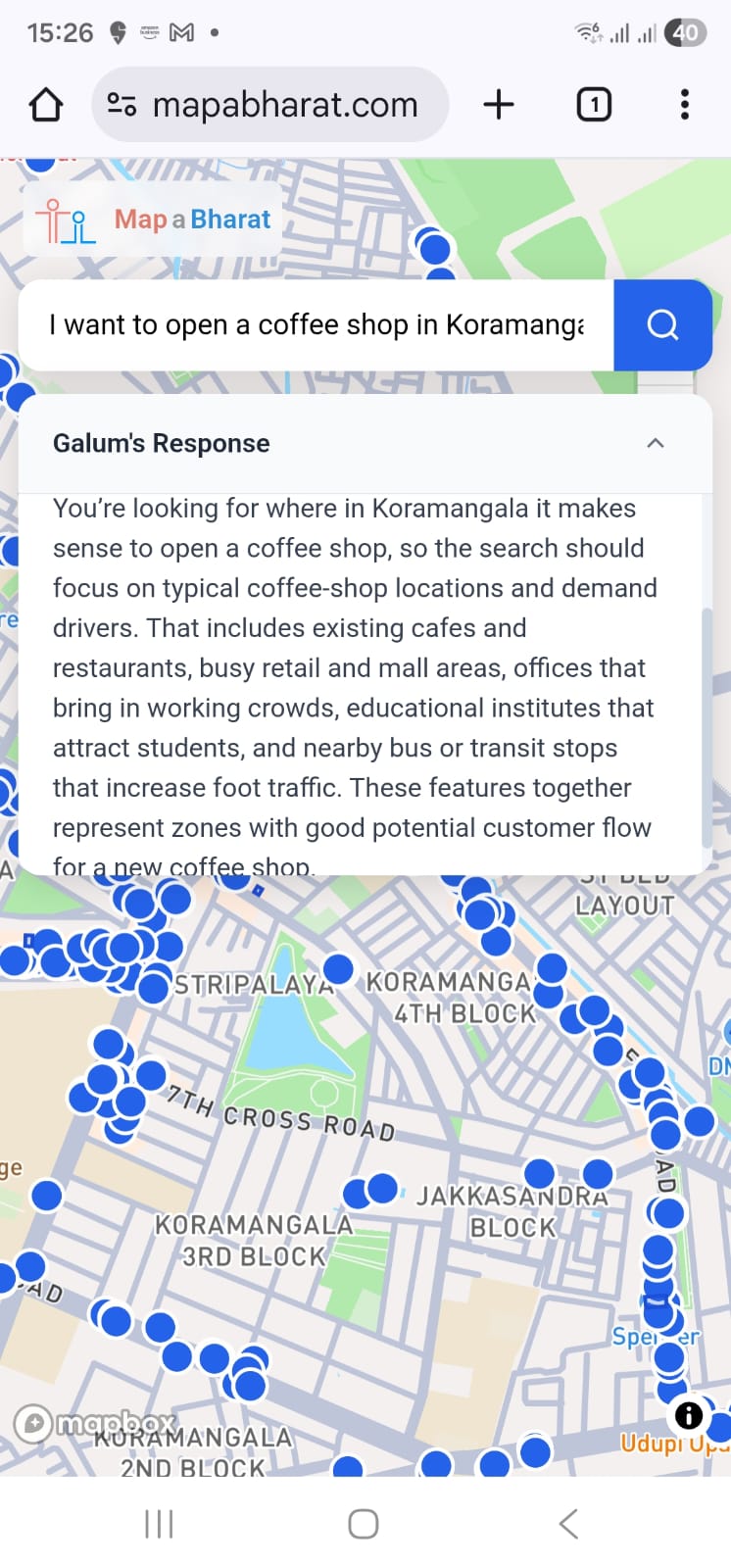
🔍 I want to open a coffee shop in Koramangala
🤖 Galum's Rationale & Interpretation

You're looking for where in Koramangala it makes sense to open a coffee shop, so the search should focus on typical coffee-shop locations and demand drivers. That includes existing cafes and restaurants, busy retail and mall areas, offices that bring in working crowds, educational institutes that attract students, and nearby bus or transit stops that increase foot traffic. These features together represent zones with good potential customer flow for a new coffee shop.

Key Architectural Highlights
  • Natural language business intent mapped to spatial footfall drivers
  • Combines competitive cafes, corporate offices, colleges, and transit nodes
  • Renders comprehensive point clusters across Koramangala 3rd & 4th Block
Source Engine: Galum v1 + OpenStreetMap View Architecture →
Key Capabilities

Beyond Keyword Pins: True Spatial Reasoning

Traditional map APIs require hardcoded category IDs and radial latitude/longitude queries. MapaBharat understands the underlying economic geography and linguistic nuances of Indian cities.

🏪

Commercial Intent & Demand Drivers

Search for business opportunities rather than mere names. Galum infers the surrounding demand factors — identifying footfall generators, transit intersections, competitors, and complementary commercial establishments.

🛣️

Corridor Routing & Geometric Buffering

Execute complex arterial queries like "amenities along highway routes within 1 km". MapaBharat combines OSRM road corridor tracing with exact vector buffer sampling to extract roadside facilities.

🇮🇳

Native Multilingual Understanding

Supports native prompts in Indian languages (Bengali, Hindi, Tamil, Telugu, Marathi, and more). Returns plain-language rationales and localized explanations without requiring translation pre-processing.

📐

Cadastral & Urban Parcel Geometry

Resolves complex polygonal boundaries including parks, university campuses, lakes, industrial estates, and residential complexes rather than collapsing locations into naive single coordinates.

🛡️

Sovereign & Vendor-Independent Data

Built on OpenStreetMap and self-hostable spatial infrastructure. Eliminates proprietary vendor lock-in, recurring per-hit map API fees, and restrictive commercial licensing constraints.

⚡

Explainable Rationale & Zero Hallucination

Every search result comes with an explicit explanation of why the area was chosen, which tags were extracted, and what spatial boundaries were enforced — ensuring auditability for enterprise teams.

Visual Step-by-Step Breakdown

From Natural Intent to High-Precision Features

Screenshots and keyframes captured directly from real MapaBharat production sessions. Observe how Galum interacts with the user, displays live reasoning spinners, and visualizes multi-layer geospatial data.

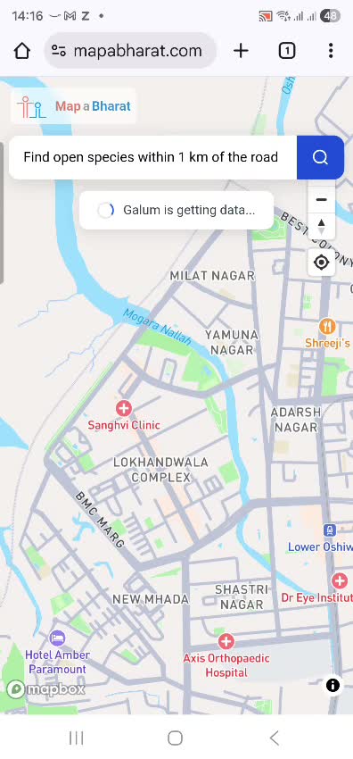
Galum is getting data status indicator

Real-Time Intent & Status Indicator

When a user asks a complex natural query (e.g. "Find open spaces within 1 km of the road"), Galum acknowledges the request asynchronously with a status indicator (Galum is getting data...) while the background execution pipeline parses the spatial geometry.
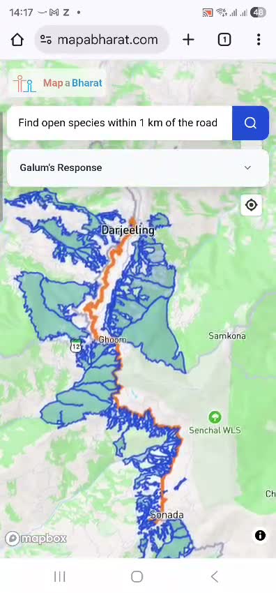
1 km road buffer corridor between Darjeeling and Sonada

Road Corridor Tracing & 1 km Vector Buffer

Galum traces the arterial road (orange LineString corridor between Darjeeling, Ghoom, and Sonada) and applies an exact 1 km geometric buffer boundary (blue outline), extracting enclosed meadows, open spaces, and natural zones along NH110.

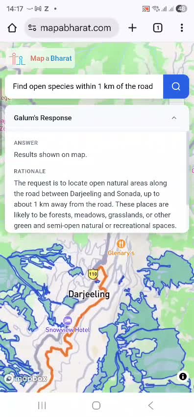
Zoomed view of corridor features in Darjeeling

Seamless Zoom & Local Topology

Users can pan and zoom directly into specific sectors of the corridor (e.g., around Glenary's and Snowview Hotel). The underlying vector tiles seamlessly render topological boundaries, roads, and reserve forest lines without latency.

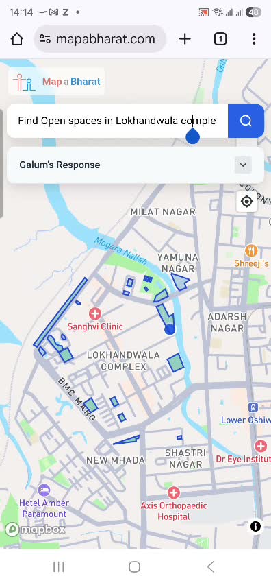
Open spaces polygon parcels in Lokhandwala Complex Mumbai

Discrete Urban Parcel Boundaries

When searching for "Open spaces in Lokhandwala Complex", Galum avoids imprecise point coordinates and instead isolates exact parcel geometries — highlighting parks, playgrounds, and recreational grounds across Andheri West.

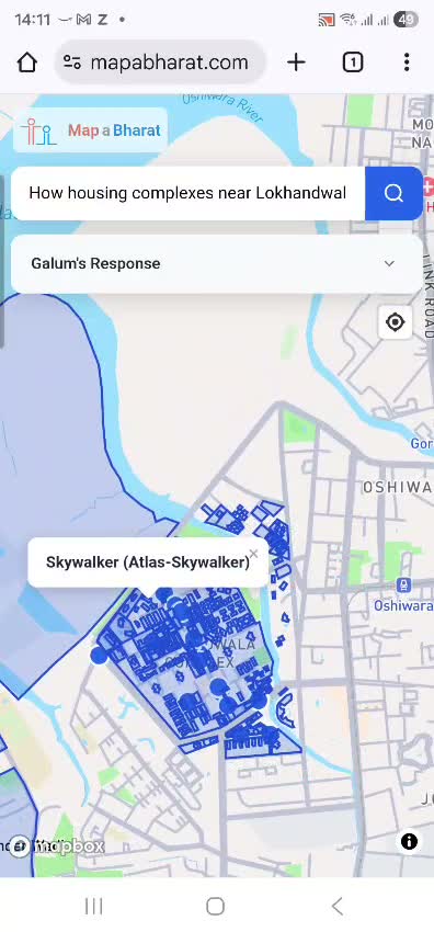
Skywalker Atlas-Skywalker building complex popup in Lokhandwala

Individual Feature Popups & Metadata

Selecting any polygon or pin opens an instant popup with verified OSM entity data (e.g. Skywalker (Atlas-Skywalker) housing enclave), allowing real estate analysts and logistics dispatchers to verify exact site coordinates.

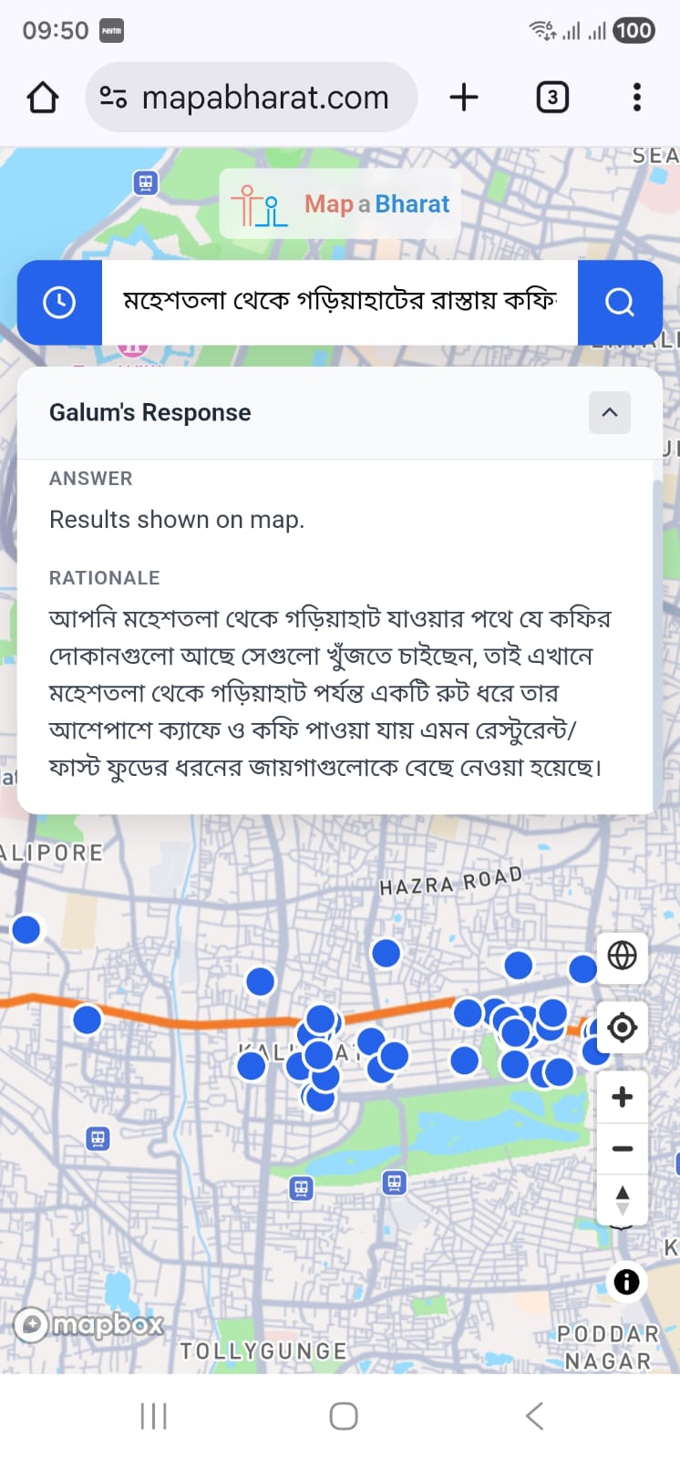
Multilingual Bengali road query from Maheshtala to Gariahat

Native Indian Language Comprehension

Galum natively understands queries written in Bengali, Hindi, Tamil, and other Indian scripts. It traces the route from Maheshtala to Gariahat in Kolkata, filters matching coffee shops, and delivers the rationale in fluent Bengali.

System Pipeline

The Galum Spatial Processing Pipeline

A four-tier pipeline connecting natural-language user semantics with high-speed GIS geometry engines and deterministic spatial databases.

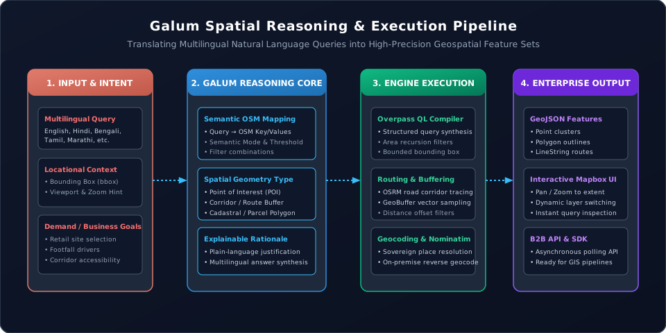
Galum Spatial Reasoning & Execution Pipeline Diagram

1. Intent Ingestion

Ingests natural language in any Indian language or English along with client viewport coordinates (bbox) and conversational session context.

2. Semantic Translation

Galum evaluates commercial intent, maps semantic tokens to OSM keys/values, chooses spatial geometry modes (Point, Route, Polygon), and drafts the rationale.

3. Spatial Compilation

Compiles Overpass QL expressions, resolves bounding areas via Nominatim geocoding, and performs corridor route sampling via OSRM vector buffering.

4. Client Delivery

Renders rich GeoJSON layers on high-performance vector maps (Mapbox GL JS) or streams structured results over asynchronous polling REST APIs.

Enterprise Solutions

Engineered for Indian B2B Workflows

Designed for retail chains, delivery aggregators, urban planning consultants, and logistics enterprises that require deep spatial insight without proprietary lock-in.

Retail Site Selection & Catchment Analysis

Commercial expansion teams can analyze footfall magnets, existing competitors, public transit corridors, and college campuses within minutes. Instead of manual surveys or rigid GIS queries, planners simply ask:

💬 "Where in Indiranagar are high-density youth footfall nodes near metro stations?"
  • Immediate cluster identification for new store placement
  • Multi-factor filtering across demographic demand drivers
  • Reduces pre-feasibility GIS reconnaissance cycles from weeks to seconds

Corridor Logistics & Infrastructure Planning

Fleet operators, cold-chain distributors, and infrastructure developers can evaluate facilities situated along transit arteries and national highways:

💬 "Find EV charging stations and heavy-vehicle bays within 2 km of NH-48 between Pune and Kolhapur"
  • Dynamic polygonal buffers following topological road networks
  • Calculates true turn-by-turn road distance rather than naive radial distance
  • Integrates seamlessly with proprietary fleet telematics pipelines